

River Kelvin Catchment Partnership (RKCP)
Working for nature, climate and people

About the Partnership
The River Kelvin Catchment Partnership brings together local authorities, public agencies, and key stakeholders with a shared commitment to improving the River Kelvin catchment through place-based action.
Acting as a catalyst for positive change, the Partnership will support the development and delivery of strategic and practical interventions across the River Kelvin catchment. By working collaboratively, the Partnership can align priorities, share skills and resources, and unlock opportunities to deliver projects at a scale to benefit of both communities and the environment.
These efforts help build climate resilience, enhance biodiversity, improve water quality, and reduce flood risk, while also creating wider benefits for people, places, and nature.
The River Kelvin Catchment
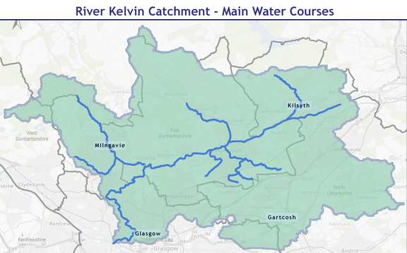
The River Kelvin, a northern tributary of the River Clyde, rises in the Kilsyth Hills about 3 miles east of Kilsyth and flows southwest for around 21 miles to join the Clyde at Partick, west of Glasgow city centre.”
The Partnership's aim is: “to create a healthy, resilient and nature-rich place that connects communities, enhances biodiversity and supports climate adaptation.”

Challenges & Solutions
Across the UK, the impacts of climate change are increasingly visible in our rivers, streams, and landscapes. Communities are experiencing more frequent flooding, periods of water scarcity, and a decline in wildlife and biodiversity.
Nature-based solutions offer a practical and sustainable way to respond to these challenges. They involve protecting, managing, and restoring natural water environments so they can better support people and nature while improving water quality, strengthening ecosystems, and helping us adapt to climate change.
Across the Glasgow City Region, there is growing recognition that identifying and delivering nature-based solutions creates an opportunity for coordinated action at “catchment-scale”. By working together—with strong leadership and active public participation—we can take a more integrated approach to managing water and landscapes across the River Kelvin catchment.
By making better use of natural systems within catchments—such as wetlands and riparian planting that help regulate water flow and filter pollution—we can develop place-based solutions that benefit both communities and the environment.
The River Kelvin Catchment Partnership has three elements

Catchment
Wetlands are crucial in helping us adapt to climate change, providing catchment-wide natural flood management

Connectivity
Targeting habitat creation will create a permeable landscape for species to move through freely

Collaboration
Successful delivery needs to happen across a range of land uses and ownerships requiring different approaches and partners
A history of the River Kelvin catchment
The history of the River Kelvin catchment reflects the wider story of western Scotland—shaped by ancient landscapes, Roman frontiers, industrial expansion, and modern regeneration. From early settlement to today’s efforts to restore nature and improve water quality, the river has continually influenced how people live, work, and move through the region.
During the Roman occupation of Britain, the Kelvin valley formed part of the northern frontier of the Roman Empire. The nearby Antonine Wall, built around AD 142 under Emperor Antoninus Pius, ran across central Scotland and crossed the Kelvin catchment.
Roman forts and fortlets were located nearby, including at Bearsden Roman Bathhouse, where soldiers used sophisticated bathing facilities supplied by local water sources. The river and its tributaries provided freshwater, natural transport corridors, and fertile land for farming.
Although Roman occupation lasted only a few decades in this area, it left an enduring archaeological footprint and established the Kelvin valley as a strategic landscape linking the west and east of Scotland.

For centuries after the Romans, the Kelvin catchment remained largely rural, characterised by farms, small settlements, and water-powered mills. This changed dramatically during the Industrial Revolution.
With the rapid growth of Glasgow in the 18th and 19th centuries, the River Kelvin became an important industrial resource. Water from the river powered mills, supported textile production, and served nearby engineering works and factories.
Key developments included:
Expansion of flour and textile mills along the river
Growth of industrial communities such as Maryhill
Construction of canals and railways linking the Kelvin valley to wider trade networks
Increased urbanisation as Glasgow became one of the British Empire’s major industrial cities
While the river enabled economic growth, industrialisation also brought pollution, altered riverbanks, and a loss of natural habitats.

By the mid-20th century, many industries along the Kelvin had declined or closed. Although this reduced some industrial pollution, it left parts of the catchment with derelict land, degraded waterways, and fragmented habitats.
At the same time, public awareness of environmental issues grew. Community groups, local authorities, and environmental organisations began to focus on:
Improving water quality
Restoring natural river habitats
Creating green corridors and public access routes
Protecting biodiversity within the catchment
The development of routes such as the Kelvin Walkway helped reconnect communities with the river.

Today the Kelvin catchment is recognised as a valuable urban blue–green corridor supporting wildlife, recreation, heritage, and climate resilience.
Collaborative initiatives—such as the River Kelvin Catchment Partnership—bring together public bodies, environmental organisations, and communities to improve the river system.
Current priorities include:
Restoring wetlands and riverbanks
Reducing flood risk through nature-based solutions
Improving water quality
Enhancing biodiversity
Creating better access to nature for local communities
The River Kelvin has therefore evolved from frontier landscape, to industrial resource, to modern environmental asset—playing a central role in the history and future of the Glasgow City Region.

Where is the River Kelvin?
Glasgow City Region spans three local authorities: East Dunbartonshire, Glasgow, and North Lanarkshire.
In total it covers a total of 21 miles and contains diverse range of landscapes including peri-urban and urban environments.
From source to Clyde from Kilsyth Hills to urban Glasgow’s West End, link. Link to industry with heritage features – for example Garrioch Viaduct
RKCP pdf (to be uploaded here)
View our other delivery projects

Developing meadow and grassland projects.

Expanding off-road routes for Green Active Travel

Restoring much of the Regions degraded peatland

Aiming to plant 18 million trees by 2032


Newsletter Signup
Learn more about GCR Green Network! You can be the first the hear about our latest news.
Designed & Built by Mucky Puddle